The World According To Google - satellite pictures of the most interesting places on the World, satellite maps: Most interesting places of the World (on google maps)

Choose category

Shortcut » Newest places | Posts with videos | Selected places | Submit interesting place

Interesting places:

Advertisements:

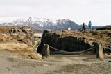
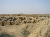
Krak des Chevaliers - a Crusader fortress, Syria

January 21st, 2008 / / Links: Google Earth, Google Maps, Yahoo! Maps, Virtual Earth / Nearest places
Share This

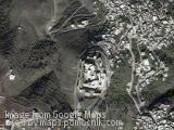
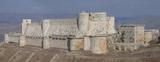
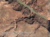
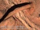
Krak des Chevaliers, also transliterated Crac des Chevaliers pronounced, is a Crusader fortress in Syria and one of the most important preserved medieval military castles in the world. In Arabic, the fortress is called Qal'at al-Ḥiṣn, the word Krak coming from the Syriac karak, meaning fortress. It is located 65 km west of the city of Homs, close to the border of Lebanon, and is administratively part of the Homs Governorate.

Krak des Chevaliers was the headquarters of the Knights Hospitaller during the Crusades. It was expanded between 1150 and 1250 and eventually housed a garrison of 2,000. The inner curtain wall is up to 100 feet thick at the base on the south side, with seven guard towers 30 feet in diameter.

King Edward I of England, while on the Ninth Crusade in 1272, saw the fortress and used it as an example for his own castles in England and Wales. The fortress was described as “perhaps the best preserved and most wholly admirable castle in the world” by T.E. Lawrence. This fortress was made a World Heritage Site, along with Qal’at Salah El-Din, in 2006 and is owned by the Syrian government. The fortress is one of the few sites where Crusader art (in the form of frescoes) has been preserved.

(more..)

The Studenica monastery, Serbia

January 15th, 2008 / / Links: Google Earth, Google Maps, Yahoo! Maps, Virtual Earth / Nearest places
Share This

The Studenica monastery (Manastir Studenica) is a Serbian Orthodox monastery situated 39 km southwest of Kraljevo, in central Serbia. It is one of the largest and richest Serb Orthodox monasteries.

Stefan Nemanja, the founder of the medieval Serb state, founded the monastery in 1190. The monastery's fortified walls encompass two churches: the Church of the Virgin, and the Church of the King, both of which were built using white marble. The monastery is best known for its collection of 13th- and 14th century Byzantine-style fresco paintings.

In 1986 UNESCO included Studenica monastery on the list of World Heritage Sites.

The monastery Studenica, dedicated to the Presentation of the Holy Virgin, is the mother-church of all Serbian temples. It was constructed over quite long period of time. The first stage works were completed by the spring of 1196, when Stefan Nemanja abandoned his throne and settled in the monastery's foundation. When he later left for Hilandar, his son and successor Stefan took over the care of Studenica. Nemanja died in Hilandar in 1199. Nemanja's third son Sava, after reconciling his brothers Stefan and Vukan, moved Nemanja's relics to Studenica. Under guardianship of Sava, Studenica became the political, cultural and spiritual center of medieval Serbia. Among his other endeavors, Sava composed a "Studenica Typikon", the rule-book where he described St. Simon's (Nemanja's) life, leaving evidence of the spiritual and monastic life of his time.

(more..)

The Royal Exhibition Building, Melbourne, Australia

December 17th, 2007 / / Links: Google Earth, Google Maps, Yahoo! Maps, Virtual Earth / Nearest places
Share This

The Royal Exhibition Building is located in Melbourne, Australia. It is located in the Carlton Gardens, at the north-eastern edge of the central business district. It was the first building in Australia to be awarded UNESCO World Heritage. It sits adjacent to the Melbourne Museum; and is the largest item in Museum Victoria's collection.

It was designed by the architect Joseph Reed (who also designed the Melbourne Town Hall and the State Library of Victoria). It was completed in 1880, ready for the Melbourne International Exhibition. The building consisted of a Great Hall of over 12,000 square metres and many temporary annexes. The landmark dome is believed to be inspired by the Florence Cathedral.

The Melbourne Centennial Exhibition was held at the Exhibition Building in 1888 to celebrate a century of European settlement in Australia.

(more..)

Pico del Teide - a volcano on Tenerife, Canary Islands, Spain

October 31st, 2007 / / Links: Google Earth, Google Maps, Yahoo! Maps, Virtual Earth / Nearest places
Share This

Teide (pronounced "Tay-dee") or Pico del Teide, is a volcano on Tenerife, Canary Islands. The volcano and its surrounds comprise the Parque Nacional del Teide, an 18,900 ha (46,703 acre) national park that was named a World Heritage Site by UNESCO on June 29th, 2007.

At 3,718 m (12,198 ft) above sea level, and approximately 7,500 m (25,000 ft) above the adjacent sea bed, Teide is the highest mountain in Spain and the highest mountain in any Atlantic island. (Note: The actual summit stands 3 m (10 ft) higher than the triangulation station, and associated bench mark, which has an altitude of 3,715 m (12,188 ft) ). The island of Tenerife itself is the third largest volcano by volume on Earth, making Tenerife the third largest volcanic island on Earth. Teide is also the third highest volcano on a volcanic ocean island.

(more..)

Þingvellir, Iceland

October 31st, 2007 / / Links: Google Earth, Google Maps, Yahoo! Maps, Virtual Earth / Nearest places
Share This

Þingvellir (Icelandic: Þing: 'parliament', vellir: 'plains') is a place in the southwest of Iceland near the peninsula of Reykjanes and the Hengill volcanic area.

The valley is one of the most important places in Icelandic history. In the year 930, the Alþingi, one of the oldest parliamentary institutions of the world, was founded here.

The Alþingi met yearly, where the Lawspeaker recited the law to all of the gathered people and decided disputes as well. Criminals were also punished at these assemblies; to this day, visitors can see the Drekkingarhylur ('drowning pool') in the river, where female lawbreakers were drowned.

Send by: Gh0st


The Curonian Spit, Lithuania/Russia

October 31st, 2007 / / Links: Google Earth, Google Maps, Yahoo! Maps, Virtual Earth / Nearest places
Share This

The Curonian Spit (Lithuanian: Kuršių Nerija, Russian: Куршская коса, German: Kurische Nehrung, Latvian: Kuršu kāpas) is a 98 km long, thin, curved sand dune peninsula that separates the Curonian Lagoon from the Baltic Sea.

The Curonian Spit stretches from the Sambian Peninsula on the south to its northern tip next to a narrow strait, across from which is the port city of Klaipėda on the mainland of Lithuania. The northern 52 km long stretch of the Curonian Spit peninsula belongs to Lithuania, while the rest is part of the Kaliningrad Oblast, Russia (see the map). The width of the spit varies from a minimum of 400 m in Russia (near the village of Lesnoye) to a maximum of 3,800 m in Lithuania (just north of Nida).

According to Baltic mythology, the Curonian Spit was formed by a strong girl, Neringa, who was playing on the shore of the sea. This child also appears in some other myths (in some of which she is shown as a young strong woman, similar to a female version of the Greek Heracles).

(more..)

Chan Chan - the largest Pre-Columbian city in South America, Peru

September 24th, 2007 / / Links: Google Earth, Google Maps, Yahoo! Maps, Virtual Earth / Nearest places
Share This

The largest Pre-Columbian city in South America, Chan Chan is an archaeological site located in the Peruvian region of La Libertad, five km west of Trujillo. Covering an area of approximately 20 km², Chan Chan was constructed by the Chimor (the kingdom of the Chimú), a late intermediate period civilization which grew out of the remnants of the Moche civilization. The vast mud city of Chan Chan was built between c.850 and c.1470 and was the imperial capital until Chimor was conquered by the Inca in the 15th century. It is estimated that 30,000 people lived in the city of Chan Chan.

The city is composed of ten walled citadels which housed ceremonial rooms, burial chambers, temples, reservoirs and some residences. Each of these citadels has a rectangular configuration with a north-facing entrance, high walls, and a labyrinth of passages.

(more..)

Amphitheatre of El Jem, Tunisia

September 5th, 2007 / / Links: Google Earth, Google Maps, Yahoo! Maps, Virtual Earth / Nearest places
Share This

El Djem is famous for its amphitheatre (often incorrectly called "a colosseum"), capable of seating 35,000 spectators. Only Rome's Colosseum (about 45,000 spectators) and the ruined theatre of Capua are larger. The amphitheatre at El Djem was built by the Romans under proconsul Gordian, who was acclaimed Emperor at Thysdrus, around 238 and was probably mainly used for gladiator shows and chariot races (like in Ben-Hur). It is also possible that construction of the amphitheatre was never finished.

Until the 17th century it remained more or less whole. From then on its stones were used for building the nearby village of El Djem and transported to the Great Mosque in Kairouan, and at a tense moment during struggles with the Ottomans, the Turks used cannons to flush rebels out of the amphitheatre.

(more..)
Close
E-mail It