The World According To Google - satellite pictures of the most interesting places on the World, satellite maps: Most interesting places of the World (on google maps)

Choose category

Shortcut » Newest places | Posts with videos | Selected places | Submit interesting place

Interesting places:

Advertisements:

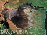
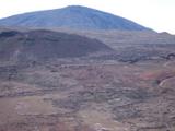
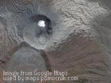
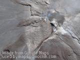
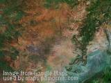
Nevado de Toluca volcano and Moon Lake, Mexico

February 22nd, 2008 / / Links: Google Earth, Google Maps, Yahoo! Maps, Virtual Earth / Nearest places
Share This

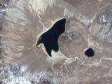
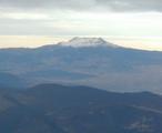
Nevado de Toluca is a large stratovolcano in central Mexico, located about 80 km west of Mexico City near the city of Toluca. It is generally cited as the fourth highest of Mexico's peaks, after Pico de Orizaba, Popocatépetl, and Iztaccíhuatl, although by some measurements, Sierra Negra is slightly higher. It is often called by the Nahuatl name Xinantécatl, "Senor Desnudo" in spanish, which is usually translated as "The Naked Lord" although other etymologies have been suggested such as" Lord of the Cornstalks" (chinām(itl) 'cornstalks' + tēcatl 'lord of').

The volcano has a 1.5 km (1 mile) wide summit caldera which is open to the west. The highest summit, 4,680 metres (15,354 ft) Pico del Fraile (Friar's Peak), is on the south side of the crater and the second highest, 4,640 metres (15,223 ft) Pico del Aguila (Eagle's Peak), is on the north. There are two crater lakes on the floor of the basin at about 4,200 m (13,800 ft), the larger Lago del Sol (Sun Lake) and the smaller, but deeper, Lago de la Luna (Moon Lake). A road runs into the caldera to the lakes, making this perhaps the most accessible major Mexican peak.

(more..)

Some object in Gobi Desert, China

February 22nd, 2008 / / Links: Google Earth, Google Maps, Yahoo! Maps, Virtual Earth / Nearest places
Share This

Some object in Gobi Desert in China. What's that?

Send by: stan


Piton de la Fournaise (Peak of the Furnace) volcano, Réunion Island, Indian Ocean

February 22nd, 2008 / / Links: Google Earth, Google Maps, Yahoo! Maps, Virtual Earth / Nearest places
Share This

Piton de la Fournaise (French: "Peak of the Furnace") is a shield volcano on the eastern side of Réunion island (a French territory) in the Indian Ocean. It is currently one of the most active volcanoes in the world, along with Kīlauea in the Hawaiian Islands (Pacific Ocean) Stromboli, Etna (Italy) and Mount Erebus in Antarctica. A recent eruption began in August 2006 and ended in January 2007. The volcano erupted again in February 2007, and most recently on 2 April 2007.

Piton de la Fournaise is often known locally as le Volcan (The Volcano); it is a major tourist attraction on Réunion island.

The top part of the volcano is occupied by the Enclos Fouqué, a caldera 8 kilometres (5 miles) wide. High cliffs known as remparts form the caldera's rim. The caldera is breached to the southeast into the sea. It is also unstable and in the initial stages of failure and will eventually collapse into the Indian Ocean. Whether it will generate a so called "mega-tsunami" is controversial. There is evidence on the submerged flanks and abyssal plain of earlier failures. The lower slopes are known as the Grand Brûlé ("Great Burnt"). Most lava eruptions are confined to the caldera.

(more..)

Mount Bromo also Gunung Bromo, Java, Indonesia

February 12th, 2008 / / Links: Google Earth, Google Maps, Yahoo! Maps, Virtual Earth / Nearest places
Share This

Mount Bromo also Gunung Bromo, located in the Tengger Caldera, is one of the most popular tourist attractions in East Java, Indonesia. It is an active volcano and part of the Tengger massif, and even though at 2329 meters it is not the highest peak of the massif, it is the most well known.

According to a local folk tale, at the end of the 15th century princess Roro Anteng from the Majapahit Empire started a separate principality together with her husband Joko Seger. They named it Tengger by the last syllables of their names. The principality did prosper, but the ruling couple failed to conceive children. In their despair they climbed Mount Bromo to pray to the gods, who granted them help, but requested the last child to be sacrificed to the gods. They had 24 children, and when the 25th and last child Kesuma was born Roro Anteng refused to do the sacrifice as promised. The gods then threatened with fire and brimstone, until she finally did the sacrifice. After the child was thrown into the crater, the voice of the child ordered the local people to perform an annual ceremony on the volcano, which is not held today.

(more..)

Mount Merapi (Gunung Merapi), Java, Indonesia

February 12th, 2008 / / Links: Google Earth, Google Maps, Yahoo! Maps, Virtual Earth / Nearest places
Share This

Mount Merapi, Gunung Merapi in Indonesian language, is a conical volcano located on the border between Central Java and Yogyakarta, Indonesia. It is the most active volcano in Indonesia and has erupted regularly since 1548. Its name means Mountain of Fire. It is very close to the city of Yogyakarta, and thousands of people live on the flanks of the volcano, with villages as high as 1700 m above sea level.

Several of its eruptions have caused fatalities. It erupted from 1992 to 2002, and a particularly large explosion killed 43 people in 1994. It began erupting again in 2006, and scientists believe a large eruption is imminent.[citation needed] In light of the hazards it poses to populated areas, it has been designated as one of the Decade Volcanoes.

[Source: ]

Send by: Jeronimo

(more..)

The Serengeti, Tanzania

January 15th, 2008 / / Links: Google Earth, Google Maps, Yahoo! Maps, Virtual Earth / Nearest places
Share This

The Serengeti ecosystem is located in north-western Tanzania and extends to south-western Kenya between latitudes 1 and 3 S and longitudes 34 and 36 E. It spans some 30,000 km.

The Serengeti hosts the largest and longest overland migration in the world, a semi-annual occurrence. This migration is one of the seven tourist travel wonders of the world.

The region contains several national parks and game reserves. Serengeti is derived from the Maasai language, Maa; specifically "Serengit", meaning "Endless Plains".

Approximately 70 larger mammal and some 500 avifauna species are found there. This high diversity in terms of species is a function of diverse habitats ranging from riverine forests, swamps, kopjes, grasslands and woodlands. Blue Wildebeests, gazelles, zebras and buffalos are some of the commonly found large mammals in the region.

(more..)

The Petra Tou Romiou (Rock of Aphrodite), Cyprus

December 23rd, 2007 / / Links: Google Earth, Google Maps, Yahoo! Maps, Virtual Earth / Nearest places
Share This

The Petra Tou Romiou (Rock of the Greek), or the Rock Of Aphrodite (as known in English), is a scenic place, located off the old Pafos-Lemesos road. It's a popular tourist spot, for its breathtaking view of the sea, and more famously the birth place of Aphrodite. Legend has it that this is the Rock from which Aphrodite mythically arose from the foams in the sea.

[Source: ]

Send by: kanenas


The Mariana Trench (or Marianas Trench), Pacific Ocean

December 23rd, 2007 / / Links: Google Earth, Google Maps, Yahoo! Maps, Virtual Earth / Nearest places
Share This

The Mariana Trench (or Marianas Trench) is the deepest known oceanic trench, with a maximum depth of about 11 km (6.8 mi), and the deepest location on the surface of the Earth's crust. It is located in the floor of the western North Pacific Ocean, to the east and south of the Mariana Islands, near Guam.

The trench forms the boundary between two tectonic plates, where the Pacific Plate is subducted beneath the Philippine Plate. The bottom of the trench is farther below sea level than Mount Everest is above it. At the bottom, the water column above exerts a pressure of 108.6 MPa, over one thousand times the standard atmospheric pressure at sea level.

[Source: ]

Send by: doc_holiday

Close
E-mail It