The World According To Google - satellite pictures of the most interesting places on the World, satellite maps: Most interesting places of the World (on google maps)

Choose category

Shortcut » Newest places | Posts with videos | Selected places | Submit interesting place

Interesting places:

Advertisements:

Gergeti Trinity Church, Georgia

March 7th, 2008 / / Links: Google Earth, Google Maps, Yahoo! Maps, Virtual Earth / Nearest places
Share This

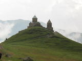
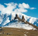
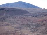
Gergeti Trinity Church is a popular name for Holy Trinity Church (Tsminda Sameba in Georgian) church near the village of Gergeti in the Republic of Georgia. The church is situated on the right bank of the river Chkheri (the left tributary of the river Terek), at an elevation of 2400 meters, under Mt. Kazbegi. It was built in the 14th century. The church is a popular waypoint for trekkers in the ar

[Source: ]

Send by: greg

More photos:


The Sambadrome (Sambódromo da Marquês de Sapucaí), Rio de Janeiro, Brazil

February 29th, 2008 / / Links: Google Earth, Google Maps, Yahoo! Maps, Virtual Earth / Nearest places
Share This

The Sambadrome (Sambódromo in Portuguese, full name Sambódromo da Marquês de Sapucaí) is a purpose-built parade area in downtown Rio de Janeiro, Brazil where samba schools parade competitively each year during Carnival. The parades attract many thousands of Brazilians and foreign tourists each year.

The Sambadrome was designed by Oscar Niemeyer and built in 1984. It consists of 700 m stretch of the Marquês de Sapucaí street converted into a permanent parade ground with bleachers built on either side for spectators. Its capacity is 65,000. The complex includes an area located at the end of the parade route, the Praça da Apoteose (Apotheosis Square), where the bleachers are set further back from the parade area, creating a square where revelers gather as they end their parade.

Outside Carnival season, the Praça da Apoteose is occasionally used as a venue for international music concerts. Notable artists who performed there include The Rolling Stones, a-ha, Roger Waters, Eric Clapton, Phil Collins, Oasis, Avril Lavigne, Nirvana, Pearl Jam and Carlos Santana. In December, the samba schools begin holding technical rehearsals at the Sambadrome, leading up to Carnival.

(more..)

The tallest chimney in the world, Ekibastuz, Kazakhstan

February 29th, 2008 / / Links: Google Earth, Google Maps, Yahoo! Maps, Virtual Earth / Nearest places
Share This

The tallest chimney in the world (419.7 meters) in Ekibastuz, Kazakhstan.

Send by: kamil


Iquitos, Peru

February 22nd, 2008 / / Links: Google Earth, Google Maps, Yahoo! Maps, Virtual Earth / Nearest places
Share This

Iquitos is the largest city in the Peruvian rainforest, with a population of around 400,000. It is the capital of Loreto Region and Maynas Province. It is generally considered the most populous city in the world that cannot be reached by road.

Located on the Amazon River, it is a mere 106 m (348 ft) above sea level even though it is more than 3,000 km (1,864 mi) from the mouth of the Amazon at Belem in Brazil, on the Atlantic Ocean. It is situated 125 km (78 mi) downstream of the confluence of the Ucayali and Marañón rivers, the two main headwaters of the Amazon River. Iquitos has long been a major port in the Amazon Basin. It is surrounded by three rivers: the Nanay, the Itaya, and the Amazon.

The city can be reached only by airplane or boat, with the exception of a road to Nauta, a small town roughly 100 km (62 mi) south. Most travel within the city itself is via bus, motorcycle, or auto rickshaw (mototaxi, motocarro or motokar). Transportation to nearby towns often requires a river trip via llevo-llevo, a small public motorised boat.

(more..)

Piton de la Fournaise (Peak of the Furnace) volcano, Réunion Island, Indian Ocean

February 22nd, 2008 / / Links: Google Earth, Google Maps, Yahoo! Maps, Virtual Earth / Nearest places
Share This

Piton de la Fournaise (French: "Peak of the Furnace") is a shield volcano on the eastern side of Réunion island (a French territory) in the Indian Ocean. It is currently one of the most active volcanoes in the world, along with Kīlauea in the Hawaiian Islands (Pacific Ocean) Stromboli, Etna (Italy) and Mount Erebus in Antarctica. A recent eruption began in August 2006 and ended in January 2007. The volcano erupted again in February 2007, and most recently on 2 April 2007.

Piton de la Fournaise is often known locally as le Volcan (The Volcano); it is a major tourist attraction on Réunion island.

The top part of the volcano is occupied by the Enclos Fouqué, a caldera 8 kilometres (5 miles) wide. High cliffs known as remparts form the caldera's rim. The caldera is breached to the southeast into the sea. It is also unstable and in the initial stages of failure and will eventually collapse into the Indian Ocean. Whether it will generate a so called "mega-tsunami" is controversial. There is evidence on the submerged flanks and abyssal plain of earlier failures. The lower slopes are known as the Grand Brûlé ("Great Burnt"). Most lava eruptions are confined to the caldera.

(more..)

Royal Crescent, Bath, England

February 18th, 2008 / / Links: Google Earth, Google Maps, Yahoo! Maps, Virtual Earth / Nearest places
Share This

The Royal Crescent is a notable residential road of 30 houses, laid out in a crescent, in the city of Bath, England. It was designed by the architect John Wood the Younger and built between 1767 and 1774. It is amongst the greatest examples of Georgian architecture to be found in the United Kingdom and is a grade I listed building. Together with his father John Wood, the Elder, John Wood the Younger was interested in occult and masonic symbolism; perhaps their creation of largest scale was their joint design of the Royal Crescent and the nearby Circus (originally called "the King's Circus"), which from the air can be observed to be a giant circle and crescent, symbolising the soleil-lune, the sun and moon. The Circus, along with Gay Street and Queens Square, forms a key shape which is also a masonic symbol.

(more..)

Pulteney Bridge, Bath, England

February 18th, 2008 / / Links: Google Earth, Google Maps, Yahoo! Maps, Virtual Earth / Nearest places
Share This

Pulteney Bridge is a bridge that crosses the River Avon, located in Bath, England and completed in 1773. It was designed by Robert Adam and is one of only four bridges in the world with shops across the full span on both sides. Shops located on the bridge include a flower shop, an antique map shop, and a juice bar.

It is named after Frances Pulteney, heiress in 1767 of the Bathwick estate across the river from Bath. Bathwick was a simple village in a rural setting, but Frances's husband William could see its potential. He made plans to create a new town, which would become a suburb to the historic city of Bath. First he needed a better river crossing than the existing ferry. Hence the bridge.

Pulteney approached the brothers Robert and James Adam with his new town in mind, but Robert Adam then became involved in the design of the bridge. In his hands the simple construction envisaged by Pulteney became an elegant structure lined with shops. Adam had visited both Florence and Venice, where he would have seen the Ponte Vecchio and the Ponte di Rialto. But Adam's design more closely followed Andrea Palladio's rejected design for the Rialto.

(more..)

Nan Madol, Micronesia

February 12th, 2008 / / Links: Google Earth, Google Maps, Yahoo! Maps, Virtual Earth / Nearest places
Share This

Nan Madol is a ruined city that lies off the eastern shore of the island of Pohnpei (presently one of the four states in the Federated States of Micronesia) and used to be the capital of the Saudeleur dynasty until about AD 1500. The city consists of a series of small artificial islands linked by a network of canals and is often called the Venice of the Pacific. The name Nan Madol means "spaces between" and is a reference to the canals that criss-cross the ruins.

Nan Madol was the ceremonial and political seat of the Saudeleur dynasty, which united Pohnpei's estimated 25,000 people. Set apart on the main island of Pohnpei, it was a scene of human activity as early as the first or second century AD. By the 8th or 9th century islet construction had started, but the distinctive megalithic architecture was probably not begun until perhaps the 12th or early 13th century.

(more..)
Close
E-mail It