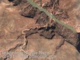
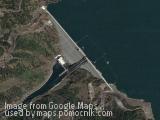
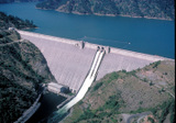
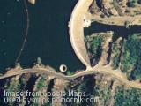
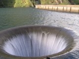
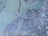
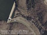
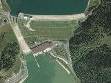
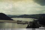
Dam and water power station in Niedzica, Poland
July 6th, 2007 / / Links: Google Earth, Google Maps, Yahoo! Maps, Virtual Earth / Nearest placesShare This
![]() |
Shortcut » Newest places | Posts with videos | Selected places | Submit interesting place
Dworshak Dam is a hydroelectric, concrete gravity dam in Clearwater County, Idaho, on the North Fork of the Clearwater River. The dam is located 4 miles (6 km) northwest of the town of Orofino, and 47 miles (76 km) east of Lewiston.
Originally the name was slated to be "Bruces Eddy," but the name was changed to honor Henry C. Dworshak, a United States Senator from Idaho. The dam is the highest straight-axis concrete dam in the Western Hemisphere and the 22nd highest dam in the world. Only two other dams in the United States exceed it in height.
Construction began in June 1966. The main structure was completed in 1972, with the generators coming online in 1973. Generating capacity is 400 megawatts, with an overload capacity of 460 MW. There are two spillway gates.
Dworshak Dam is part of the Columbia River Basin system of dams. Dworshak Reservoir is formed behind the dam. The lake stretches 53 miles (85 km) upstream. The North Fork of the Clearwater River runs 2 miles (3 km) downstream from the base of the dam, where it joins the the Clearwater, which flows to the Snake River at Lewiston.
The Morning Glory Spillway and Monticello Dam is a dam in Napa County in California.
The dam is notable for its classic, uncontrolled "glory hole" spillway with a rate of 48,400 cubic feet per second (1370 m³/s) and a diameter at the lip of 72 feet (22 m). The eerie appearance of the spillway in operation attracts visitors, and when the spillway is dry the outlet downstream is popular with skateboarders (although using the spillway for this purpose is illegal).
[Source: ]
Send by: Fidel
The Gezhouba Water Control Project is located in the suburbs of Yichang City in central China's Hubei province.
Here, after rushing out of Nanjin Pass, the Yangtze River slows down and widens from 300 m to about 2,200 m at the dam site. Two small islands, Gezhouba and Xiba, divided the river into three channels. There the Gezhouba Project was built.
Construction started on December 30, 1970 and ended on December 10,1988. It boasts a generating capacity of 2.71 GW along with three ship locks, two power stations that generate 14,100 GWh of electricity annually, the 27 gates of the spillway, and the no flowing Dam on both banks. The dam is 2,595 m long with a maximum height of 47 m. The reservoir has a total volume of 1.58 km³.
The navigation lock No. 2 on the third channel was, when built, among the 100 largest in the world. The lock chamber is 280 m long and 34 m wide, with a minimum draft of 5 m at the sill. It provides passage for ships of 10.000 tons.
The Lagan Weir, completed in 1994, at a cost of £14m, is located across the Lagan between the Queen Elizabeth Bridge and the M3 bridge (completed around the same time) in Belfast, Northern Ireland. The Lagan Weir was jointly funded by the Corporation and the European Commission it was constructed by Charles Brand Ltd and designed by Ferguson and McIlveen.
The weir is a series of massive steel barriers which are raised as the tide retreats to keep the river at an artificially constant level. This improvement to the sewerage system combined with massive dredging of the river by mechanical excavators, and installation of an underwater aeration system, has lead to a marked improvement in water quality and the environment around the river.
The objective of the structure is to keep the level of the river artificially constant, as it is a tidal river the level of the water varied by up to three metres between high and low tide. This exposed mudflats which were unsightly and emitted a strong odour, particularly in the summer months. The transformation of the riverside by the construction of the weir has been a catalyst for development along the riverside. Another part of the project is the “Lagan Lookout” centre which explains the history and function of the weir as well as the history of the Lagan itself.
The World According To Google - satellite pictures of the most interesting places on the World, satellite maps running on
This site is not affiliated with Google. This is hobby database of google satellite places locations all over the World
RSS: Entries & Comments.

Leave a passing comment »