The World According To Google - satellite pictures of the most interesting places on the World, satellite maps: Most interesting places of the World (on google maps)

Choose category

Shortcut » Newest places | Posts with videos | Selected places | Submit interesting place

Interesting places:

Advertisements:

Iquitos, Peru

February 22nd, 2008 / / Links: Google Earth, Google Maps, Yahoo! Maps, Virtual Earth / Nearest places
Share This

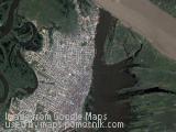
Iquitos is the largest city in the Peruvian rainforest, with a population of around 400,000. It is the capital of Loreto Region and Maynas Province. It is generally considered the most populous city in the world that cannot be reached by road.

Located on the Amazon River, it is a mere 106 m (348 ft) above sea level even though it is more than 3,000 km (1,864 mi) from the mouth of the Amazon at Belem in Brazil, on the Atlantic Ocean. It is situated 125 km (78 mi) downstream of the confluence of the Ucayali and Marañón rivers, the two main headwaters of the Amazon River. Iquitos has long been a major port in the Amazon Basin. It is surrounded by three rivers: the Nanay, the Itaya, and the Amazon.

The city can be reached only by airplane or boat, with the exception of a road to Nauta, a small town roughly 100 km (62 mi) south. Most travel within the city itself is via bus, motorcycle, or auto rickshaw (mototaxi, motocarro or motokar). Transportation to nearby towns often requires a river trip via llevo-llevo, a small public motorised boat.

(more..)

Bam - a city in Kerman Province of Iran

February 22nd, 2008 / / Links: Google Earth, Google Maps, Yahoo! Maps, Virtual Earth / Nearest places
Share This

Bam is a city in Kerman Province of Iran. The city is the center of Bam County. The modern Iranian city of Bam surrounds the Bam citadel. Before the 2003 earthquake the official population count of the city was of around 90,000. There are various opinions about the date and reasons for the foundation of the citadel. Some people believe that Bam city was founded during the Parthian empire, a very powerful Persian empire, that ruled from 250 BCE to 226 CE. Economically and commercially, Bam occupied a very important place in the region and was famed for its textiles and clothes. Ibn Hawqal (943–977), the Arab traveller and geographer, wrote of Bam in his book Surat-ul-`ard (The Earth-figure):

Over there they weave excellent, beautiful and long-lasting cotton cloths which are sent to places all over the world There they also make excellent clothes, each of which costs around 30 dinars; these are sold in Khorasan, Iraq and Egypt.

(more..)

Rudniki, Poland

February 22nd, 2008 / / Links: Google Earth, Google Maps, Yahoo! Maps, Virtual Earth / Nearest places
Share This

Rudniki - small village in Poland, near Zawiercie.

Send by: Barto11


Leicester, England

February 18th, 2008 / / Links: Google Earth, Google Maps, Yahoo! Maps, Virtual Earth / Nearest places
Share This

Leicester is the largest city and unitary authority area in the English East Midlands. The city is the traditional county town of Leicestershire.

Leicester lies on the River Soar and at the edge of the English National Forest. In 2004, the population of the city proper was estimated at 285,100, with 441,213 living in the urban area. It is currently, by population, the 10th largest city in England and the 13th largest in the UK.

The urban area extends beyond the boundaries of the city proper to include the satellite towns of Oadby, Wigston, Braunstone Town, Birstall, Glenfield, Blaby, Thurmaston, Syston and Leicester Forest East. A number of these towns are in fact closely integrated suburbs of the city itself, especially Glenfield and Braunstone. For areas within the city, see Areas of Leicester. In terms of population within the city limits it is the largest in the East Midlands.

(more..)

Domaniewek, Poland

February 12th, 2008 / / Links: Google Earth, Google Maps, Yahoo! Maps, Virtual Earth / Nearest places
Share This

Domaniewek - small village in Poland.

Send by: slawek


Utica, Tunis

January 21st, 2008 / / Links: Google Earth, Google Maps, Yahoo! Maps, Virtual Earth / Nearest places
Share This

Utica is an ancient city northwest of Carthage near the outflow of the Medjerda River into the Mediterranean Sea, traditionally considered to be the first colony founded by the Phoenicians in North Africa. Today, Utica no longer exists, and its remains are located not on the coast where it once lay, but further inland because the Medjerda River caused the silting over of its original port.

Utica's beginnings

Utica was founded as a port located on the trade route leading to the Straits of Gibraltar and the Atlantic, thus facilitating Phoenician trade in the Mediterranean. The actual founding date of Utica is controversial. Several classical authors date its foundation around 1100 BC. The archaeological evidence, however, suggests a foundation no earlier than the eighth century BC. Although Carthage was later founded about 40 km. from Utica, records suggest “that until 540 BC Utica was still maintaining political and economic autonomy in relation to its powerful Carthaginian neighbor”. By the fourth century BC, Utica came under Punic control but continued to exist as a privileged ally of Carthage.

(more..)

Ancient Roman Town of Thuburbo Major, Tunis

January 21st, 2008 / / Links: Google Earth, Google Maps, Yahoo! Maps, Virtual Earth / Nearest places
Share This

Thuburbo Majus (or Thuburbo Maius) is a large Roman site in northern Tunisia. It is located roughly 60 km southwest of Carthage on a major African thoroughfare. This thoroughfare connects Carthage to the Sahara. Other towns along the way included Sbiba, Sufes, Sbeitla, and Sufetula. Parts of the old Roman road are in ruins, but others do remain. Romans started to build Thuburbo Majus in 27 BC.

Thuburbo Majus or Colonia Julia Aurelia Commoda, its Roman name, was originally a Punic town, later founded as a Roman veteran colony by Augustus in 27 BC. Military veterans were sent to Thuburbo, among other sites, by Augustus to allow them to start their post-army lives with land of their own. Its strategic location and access to trade routes made it an important establishment. Ruins of the town are in the middle of the countryside with no towns in close proximity.

(more..)

Biala, Poland

January 15th, 2008 / / Links: Google Earth, Google Maps, Yahoo! Maps, Virtual Earth / Nearest places
Share This

Biala - small village in southern Poland.

Send by: natka

Close
E-mail It