The World According To Google - satellite pictures of the most interesting places on the World, satellite maps: Most interesting places of the World (on google maps)

Choose category

Shortcut » Newest places | Posts with videos | Selected places | Submit interesting place

Interesting places:

Advertisements:

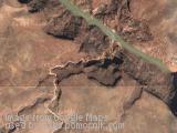
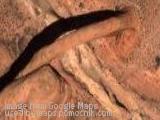
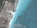
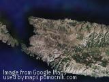
Tulum Mayan Ruins, Mexico

March 7th, 2008 / / Links: Google Earth, Google Maps, Yahoo! Maps, Virtual Earth / Nearest places
Share This

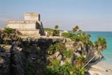
The ruins are located on 39-ft (12-m) cliffs, along the east coast of the Yucatán Peninsula on the Caribbean Sea in the state of Quintana Roo, Mexico. One of the best-preserved coastal Maya sites, Tulum is today a popular site for tourists.

The Maya site may have been formerly also known by the name Zama, meaning city of Dawn. Tulúm is also the Yucatec Mayan word for fence or wall (or trench), and the walls surrounding the site allowed the Tulum fort to serve as a defense against invasion. From the numerous depictions in murals and other works around the site, Tulum appears to have been an important site for the worship of the Diving or Descending God.

While an inscription dated A.D. 564 has been found at the site, most of the structures now visible were built in the Post-Classic Era, between about 1200 and 1450. The city remained occupied through the early years of the Spanish conquest of Yucatán, but was abandoned by the end of the 16th century. Local Maya continued to visit the temples, to burn incense and pray, until the late 20th century, when tourists visiting the site became too numerous for the local inhabitants.

(more..)

Tula, Mexico

March 7th, 2008 / / Links: Google Earth, Google Maps, Yahoo! Maps, Virtual Earth / Nearest places
Share This

Photo: Columns in the form of Toltec warriors in Tula

Tula is a town of 28, census) in the southwestern part of the state of Hidalgo in central Mexico, some 100 km to the north-northwest of Mexico City. The modern town is known as Tula de Allende; also a state municipality that covers part of the southeastern portion of the Pre-Columbian city. The present-day municipality has a population of 93,296 and an areal extent of 305.8 km² (118.07 sq mi), which includes numerous smaller outlying towns, the largest of which are El Llano, San Marcos, and San Miguel Vindho.

Nearby are the remains of the ancient capital city of the Toltecs, also known as "Tula" or as "Tollan". Usually identified as the Toltec capital around 980 CE, the city was destroyed at some time between 1168 or 1179.

The site is at and around the junction of two rivers, the Río Rosas and the Río Tula. The two largest clusters of grand ceremonial architecture are nicknamed "Tula Grande" (the most visited by tourists) and "Tula Chico". Remains of other buildings extend for some distance in all directions. In the residential areas streets were laid out in a grid pattern.

(more..)

Palenque, Mexico

March 7th, 2008 / / Links: Google Earth, Google Maps, Yahoo! Maps, Virtual Earth / Nearest places
Share This

Palenque (Bàak' in Modern Maya) is a Maya archeological site near the Usumacinta River in the Mexican state of Chiapas, located at [show location on an interactive map] 17°29′0″N, 92°2′59″W about 130 km south of Ciudad del Carmen (see map). It is a medium-sized site, much smaller than such huge sites as Tikal or Copán, but it contains some of the finest architecture, sculpture, roof comb and bas-relief carvings the Maya produced.

Much of the Early Classic history of the city still awaits the archaeologist's trowel. However, from the extent of the surveyed site and the reference to Early Classic rulers in the inscriptional record of the Late Classic, it is clear Palenque's history is much longer than we currently know. The fact that early ajaw (king or lord) and mythological beings used a variety of emblem glyphs in their titles indeed suggests a complex early history. For instance, K'uk' B'ahlam the supposed founder of the Palenque dynasty is called a Toktan Ajaw in the text of the Temple of the Foliated Cross.

(more..)

The Mayan village of Yaxunah, Mexico.

March 7th, 2008 / / Links: Google Earth, Google Maps, Yahoo! Maps, Virtual Earth / Nearest places
Share This

The Mayan village of Yaxunah in Mexico. It is located just south of Chichen Itza.

Send by: berg


Some kind of crater or water reservoir, Australia

March 7th, 2008 / / Links: Google Earth, Google Maps, Yahoo! Maps, Virtual Earth / Nearest places
Share This

Some kind of crater or water reservoir in Australia.

Send by: dago


La Digue, Seychelles, Indian Ocean

March 7th, 2008 / / Links: Google Earth, Google Maps, Yahoo! Maps, Virtual Earth / Nearest places
Share This

La Digue is the fourth largest inhabited island of the Seychelles, lying east of Praslin and west of Felicite Island. It has a population of about 2,000 people, who mostly live in the west coast villages of La Passe (linked by ferry to Praslin and Mahé) and La Réunion. It has an area of 10 sq km. La Digue is named after a ship in the fleet of French explorer Marc-Joseph Marion du Fresne, who visited the Seychelles in 1768.

Today the island's main industry is tourism and is known for its beaches especially Anse Source d'Argent. In former times copra and vanilla production were mainstays of the local economy; which is commemorated in the island's museum. In the island's interior is Veuve Nature Reserve, home of the rare Black Paradise Flycatcher, of which there are only about 100 in existence. La Digue's tallest peak is also in the central part of the island, Belle Vue (Eagle's Nest Mtn) which is more than 300 meters above sea level.

(more..)

Milna, Brac, Croatia

March 7th, 2008 / / Links: Google Earth, Google Maps, Yahoo! Maps, Virtual Earth / Nearest places
Share This

Milna is a village and municipality on the western side of island of Brač, Split-Dalmatia county, Croatia.

Brač - is an island in the Adriatic Sea within Croatia, with an area of 396 km², making it the third largest island in the Adriatic, and thus the largest in Dalmatia. Its tallest peak, Vidova Gora, or Mount St. Vid, stands at 778 m, making it the highest island point in the Adriatic. The island has a population of 13,000, living in numerous little towns, ranging from the 'main town' Supetar, with more than 3,500 inhabitants, to Novo Selo, where only a dozen people live.

[Source: ]

[Source: ]

Send by: malgorzata


Gergeti Trinity Church, Georgia

March 7th, 2008 / / Links: Google Earth, Google Maps, Yahoo! Maps, Virtual Earth / Nearest places
Share This

Gergeti Trinity Church is a popular name for Holy Trinity Church (Tsminda Sameba in Georgian) church near the village of Gergeti in the Republic of Georgia. The church is situated on the right bank of the river Chkheri (the left tributary of the river Terek), at an elevation of 2400 meters, under Mt. Kazbegi. It was built in the 14th century. The church is a popular waypoint for trekkers in the ar

[Source: ]

Send by: greg

More photos:

Close
E-mail It