Magawish Hotel, Hurghada, Egypt
October 31st, 2007 / / Links: Google Earth, Google Maps, Yahoo! Maps, Virtual Earth / Nearest placesShare This
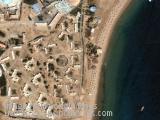
Magawish Hotel in Hurghada, Egypt
Send by: joanna, anilec

 |
Shortcut » Newest places | Posts with videos | Selected places | Submit interesting place
Interesting places:

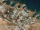
Magawish Hotel in Hurghada, Egypt
Send by: joanna, anilec
Desert Rose 5* Hotel in Hurghada, Egypt.
Send by: andrzej
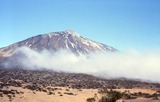
Teide (pronounced "Tay-dee") or Pico del Teide, is a volcano on Tenerife, Canary Islands. The volcano and its surrounds comprise the Parque Nacional del Teide, an 18,900 ha (46,703 acre) national park that was named a World Heritage Site by UNESCO on June 29th, 2007.
At 3,718 m (12,198 ft) above sea level, and approximately 7,500 m (25,000 ft) above the adjacent sea bed, Teide is the highest mountain in Spain and the highest mountain in any Atlantic island. (Note: The actual summit stands 3 m (10 ft) higher than the triangulation station, and associated bench mark, which has an altitude of 3,715 m (12,188 ft) ). The island of Tenerife itself is the third largest volcano by volume on Earth, making Tenerife the third largest volcanic island on Earth. Teide is also the third highest volcano on a volcanic ocean island.
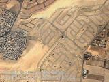
Housing estates - new and one being built in Cairo, Egypt.
Send by: FK
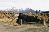
Þingvellir (Icelandic: Þing: 'parliament', vellir: 'plains') is a place in the southwest of Iceland near the peninsula of Reykjanes and the Hengill volcanic area.
The valley is one of the most important places in Icelandic history. In the year 930, the Alþingi, one of the oldest parliamentary institutions of the world, was founded here.
The Alþingi met yearly, where the Lawspeaker recited the law to all of the gathered people and decided disputes as well. Criminals were also punished at these assemblies; to this day, visitors can see the Drekkingarhylur ('drowning pool') in the river, where female lawbreakers were drowned.
Send by: Gh0st
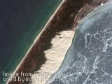
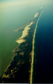
The Curonian Spit (Lithuanian: Kuršių Nerija, Russian: Куршская коса, German: Kurische Nehrung, Latvian: Kuršu kāpas) is a 98 km long, thin, curved sand dune peninsula that separates the Curonian Lagoon from the Baltic Sea.
The Curonian Spit stretches from the Sambian Peninsula on the south to its northern tip next to a narrow strait, across from which is the port city of Klaipėda on the mainland of Lithuania. The northern 52 km long stretch of the Curonian Spit peninsula belongs to Lithuania, while the rest is part of the Kaliningrad Oblast, Russia (see the map). The width of the spit varies from a minimum of 400 m in Russia (near the village of Lesnoye) to a maximum of 3,800 m in Lithuania (just north of Nida).
According to Baltic mythology, the Curonian Spit was formed by a strong girl, Neringa, who was playing on the shore of the sea. This child also appears in some other myths (in some of which she is shown as a young strong woman, similar to a female version of the Greek Heracles).
Airplane in flight near Auckland International Airport in New Zealand
Send by: Marecki
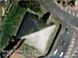
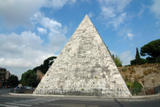
The Pyramid of Cestius (in Italian, Piramide di Caio Cestio or Piramide Cestia) is an ancient pyramid in Rome, Italy near the Porta San Paolo and the Protestant Cemetery. It stands in a fork between two ancient roads, the Via Ostiensis and another road that ran west to the Tiber along the appoximate line of the modern Via della Marmorata. Due to its incorporation into the city's fortifications, it is today one of the best-preserved ancient buildings in Rome.
The pyramid was built about 18 BC-12 BC as a tomb for Gaius Cestius Epulo, a magistrate and member of one of the four great religious corporations at Rome, the Septemviri epulonum. It is of brick-faced concrete covered with slabs of white marble standing on a travertine foundation, measuring 100 Roman feet (30 m) square at the base and standing 125 Roman feet (36.4 m) high.
Leave a passing comment »